-
The best Nikon, Mamiya and Fuji cameras and Vibration Reduction lenses for crisp detail in each frame.
-
Your choice of virtually any file format, from geotiff to jpeg and digital video.
-
All film formats available, from black & white to infrared.
-
Highest resolution necessary, customized to your needs. Standard altitude images are one-half meter per pixel or better.
-
Vertical (straight down) and/or oblique (with horizon) views for your project.
Archival Giclee Prints on Paper or Canvas
Premium
quality Epson papers, canvas, and ink · Guaranteed 85 years under
glass
Large formats and posters, even wallpaper of favorite landscapes
Fast turnaround · Framing and matting available
A handsome framed photo of your family or friend's home or ranch makes
a treasured gift.
|
|
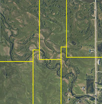
Georeferenced
Imagery and The high resolution and accuracy of these aerial photographs make them excellent for surveys of vegetation, livestock, wildlife, pipelines, and watersheds. Also essential for community planning and industry. |
|
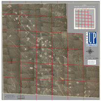 |
Energy
Production Georeferenced mosaic of one township of the Pinedale Anticline, showing exact locations of gas wells, roads, and infrastructure on the terrain. Section lines overlaid in red. Used to measure well site "footprint" for project planning. |
|
 |
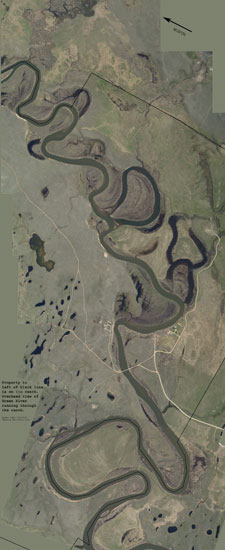
Fisheries
Management For more information on Geographic Information Systems, visit www.gis.com.. |
|
Our Garmin GPS (Global Positioning System) triangulates exact location in latitude and longitude with radio transmitted information from orbiting satellites. Our Nikon D2Xs is connected to a Garmin 396 for immediate latitude/longitude acquisition in the metadata of each image file.
We
fly a grid using GPS and integrate Red
Hen's Media Mapper Software for time and location.
The camera-shooting software is synchronized to provide consistent overlap
in acquisition of imagery.
About
Us
Rita Donham and Jamie Burgess have bachelor's degrees in photography and
business management, plus over 11,000 hours and more than 45 years cumulative
flight experience.
Wyoming
Aero Photo LLC is a woman-owned business.
![]()
Member, Aircraft Owners and Pilots Association
![]()
Member, Professional
Aerial Photographers Association
CCR Registered. DUNS: 12-126-7996. NAICS codes: 541370. 541921 Aerial Mapping and Aerial Photography. SIC code: 7335 Commercial Photography.
![]()
Rita Donham, Owner
307-231-1326
or 307-360-3049
• P.O.
Box 33, Cora WY 82925
reet@wyomingaerophoto.com
www.wyomingaerophoto.com
All images copyright Wyoming Aero Photo LLC/Rita Donham. May not be used without permission.